by Scott Lance
Kind of a long read, but hopefully you’ll find it useful…
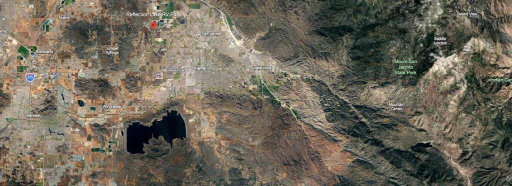
I’m occasionally asked “how high do you need to be to make it back from the S ridge” or “how high should you be to go from Mt San Jacinto to Mt San Gorgonio”, etc. So, here’s a good way to get a general idea of what altitude you need to make it back to the airport from some of the more common landmarks in and around the Hemet Valley:
First, you need to consider the aircraft you’re flying. A Krosno has an L/D of about 27/1, so let’s use that performance figure, do some simple math, and apply it to a few places we commonly go on flights out of Hemet.
The club has a guideline rule that you should plan on just 70% of the published glide ratio, so 27/1 becomes 19/1.
If we divide 5,280 (the number of feet in a statute mile) by 19, we get 278 feet lost per statute mile of distance flown (or if you prefer nautical miles, 6,076 ft / 19 = 320).
So, if we’re 10 statute miles away from the airport we should plan on burning 2,780 ft (10 x 278) getting back. To figure out if we’re high enough we also need to consider the airport is 1,500 msl and we want to arrive 1,000 to 1,500 above the airport to execute a proper landing pattern, so we should add 2,500 or 3,000 ft (airport altitude plus pattern altitude) to whatever we’re going to burn getting back.
I like using 3,000 msl for an airport arrival altitude, so 2,780 (altitude burn) + 3,000 (pattern altitude) = 5,780 which therefore is the minimum altitude (msl) we should be at 10 statute miles away (10 nautical miles would work out to 3,200 + 3,000 = 6,200).
Using a 3,000 ft msl arrival altitude, here’s what it works out to for a few places nearby:Alt (msl)
Location Distance
3,973 Reflection Lake 3.5 sm
4,390 Park Hill 5.0 sm
5,085 S Ridge 7.5 sm
7,170 Elsinore 15.0 sm
Keep in mind the math above assumes there is no wind, and the altitudes are the minimums you should use (higher is better).
Anything below the altitudes outlined above would be considered a cross country flight which has quite a few additional requirements per club rules.
Review the document titled “Cross Country Training” on the club website under the ‘Resources’ heading to see the guidelines/requirements for cross country flying in club equipment, and an excellent example of how to do a graphic flight profile to determine safe altitudes and decision points.
Since there is almost always some wind, we need a way to calculate it’s impact on our glide and altitude requirements. The flight profile calculation in the “Cross Country Training” document does an excellent job of that, but there’s another method that works pretty well and can be done on the fly. Simply compare the headwind to your best L/D speed to get an idea of how much of your performance is consumed by the headwind. For instance, if your best L/D speed is 50 knots and you’re flying into a 5 knot headwind, roughly 10% (5 divided by 50) of your performance goes into fighting the headwind so you should increase your altitude requirement by 10%. That would increase the ~5,100 required from the S ridge to more like 5,600 in a Krosno. It’s overly simple but works pretty well.
Applying that logic flying a Krosno back from Park Hill (last turnpoint doing the Hemet Triangle in a clockwise direction) you’ll want to be about 4,400 msl (minimum) at Park Hill in no wind, or somewhere around 5,300 in a 5-10kt headwind like you would probably experience on a typical summer afternoon (don’t forget to add ½ the headwind speed to your best L/D speed to get the correct speed to fly!). One of the great things about the Hemet Triangle and using Park Hill as the last turnpoint is the option to make the return leg a long final approach (instead of flying a standard pattern) and come straight in to land if you get low. 5,500 msl at Park Hill will generally keep you comfortably safe and in good position to finish the triangle and make a normal pattern though. If you’re on the leg from Reflection Lake to Park Hill and you start getting down to around 5k, you should probably abandon the task (at least temporarily) and head closer to the airport until you find lift and gain altitude (at which time you might be able to resume course to Park Hill) or are safely in position to enter the pattern and land.
Speed to fly becomes increasingly important as you get farther away from the airport! The optimum speed to fly will minimize your altitude loss in adverse conditions and maximize your distance over the ground. A general/universal guideline for speed to fly is to simply speed up in sink and slow down in lift (the basic idea is to minimize the time you spend in sink and maximize the time you spend in lift) and the rule of thumb is to use best L/D speed and add 5kts for every extra 100 fpm of sink. As an example (including a headwind), if your best L/D speed is normally 50kts and you’re flying into a 10kt headwind, your new best L/D speed is 55kts to compensate for the headwind (which will probably result in ~ 250 fpm down on the vario), but you hit sinking air and the vario now says 450 fpm down (an extra 200 fpm), you’d want to increase airspeed to 65kts (55+5+5) until you flew out of the sink at which time you could slow back down to 55kts.
Since all these calculations are based on distance, it’s pretty critical that you know how far away the airport is. Any good GPS device (including a smart phone) can do that job, but a simple area map (remember those?) or sectional chart with concentric circles drawn every mile or two can also work very well. Constantly doing math in the cockpit can be distracting and tiring, so most pilots fly with a flight computer that does the distance/altitude calculations constantly and displays how much you are above (or below) the altitude you need to glide to your destination, but it’s important to have a backup (like a map) and be able to do the calculations manually just in case the computer fails. There are a variety of good flight computers and several great reasons to use one, but that’s a whole subject of it’s own…
The 1-34, PW6, and Grob all have a glide ratio of around 34/1, which adjusts to 23.8/1 with the 70% safety factor, which calculates to about 222 ft per mile. Applying that to a few landmarks gives:Alt (msl)
Location Distance
3,777 Reflection Lake 3.5 sm
4,110 Park Hill 5.0 sm
4,665 S Ridge 7.5 sm
5,664 Poppet Flats 12.0 sm
6,663 Black Mtn Fire Lookout 16.5 sm
7,440 Mt San Jacinto 20.0 sm
6,330 Elsinore 15.0 sm
8,328 Mt San Gorgonio 24.0 sm
9,216 Mt Palomar 28.0 sm
10,992 Warner Springs 36.0 sm
If you’re working your way from the S Ridge to Mt San Jac (the most typical way up there), Poppet Flats and the Black Mtn Fire Lookout are key points along the way but since the fire lookout is at 7,777 ft (and you only need 6,663 to get back) you can see that once you cross hwy 243 (the road from Banning to Idyllwild) you can make it back to Hemet from pretty much anywhere on the mountain.
To answer the question about how high you need to be above San Jac to go to San Gorgonio, let’s take the roughly 8,400 (minimum, in the higher performance gliders) you need to get back to the airport from San Gorgonio (in case there’s no lift there) and add the 4,400 you’ll need to cover the 20 miles from peak-to-peak: 8,400 + 4,400 = 12,800
So, at minimum, you should be 2,000 above San Jac (that would be 12,800 msl) before heading to San Gorgonio. As always though, higher is better. You could try to get across from less than 12,800 and just turn around if you start getting too low, but Banning Pass rarely produces lift so you’re going to want all the altitude you can get at San Jac. Also, Banning Pass is a high traffic area for commercial flights coming into Ontario and San Bernardino so I usually try to cross as straight and fast as I can to avoid encounters with other aircraft.
Regards and hope this helps,
Scott L.